![]()

Smart Village
Crime map System and crime/danger analysis service platform based on location warning system integrating the modules of Intelligent IEMS (CTS, ARS, CAD, MRS, LBS, Intelligent VAS, ANPR)
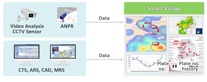
ANPR
- Analysis of crime data based on incident registered by CTS and ARS, and CAD dispatch order data
- CCTV Video Analysis System - Data analysis
- Support which shares the situation in real time, and location-based alarm service
- Supports crime map
-
- Crime mapping by classification, time-based statistics for the area, crime trends in the area, search of statistical tables
- Predictive crime mapping, predictive mapping by area and crime classification, predictive mapping based on time of day
- Geo-time fence in risk areas
- Crime and risk analysis service
-
- Algorithms for analysis of crime risk areas
- Crime prediction model
- Evaluation algorithm on risk exposure
- Sharing information with local residents
Features
- Possibility of adding more information besides CTS, ARS, CAD
- Option of sending detection videos for video analysis, tracking of vehicles and pedestrians as mega data
- Application of algorithm for pattern analysis (structured data and unstructured) to predict crime
- Establish model for evaluation of risk/danger level of crime
- Real-time and localized risk alarm service
- Strategic crime prevention solution using operational data from the CTS, ARS, CAD, MRS, LBS, ANPR and Intelligent Video Analysis modules
© WINITECH Co., Ltd All right reserved
(Bon-dong, Daegu Technical University, Welfare center 2F), 205, Songhyeon-ro, Dalseo-gu, Daegu, Korea
Tel : 82-53-659-1700FAX : 82-53-659-1707